Tyrolean Software Company General Solutions Been Offering New Vector Based Map
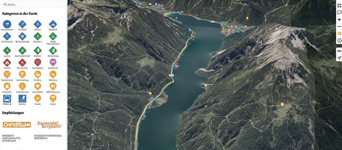
Since February 2023, the Tyrolean software company General Solutions has been offering its customers a new vector-based map basis and is playing a pioneering role in international comparison. The digital map is integrated into the interactive touristic solution Contwise Maps. With the interactive map solution, guests and residents plan excursions and activities in the holiday regions. More than 40 tourism organizations in Austria and Italy rely on the card solution for guest communication. Together with the Contwise Infra software for the administration, maintenance and management of tourism infrastructure, General Solutions covers the needs of the industry in a targeted manner.
Since 1989, General Solutions has been the innovative partner for tailor-made software solutions in the areas of tourism, destination, crisis and deployment management. With the latest technology and many years of know-how, the Tyrolean company, headquartered in Landeck, increases the communication and security standards of its customers. With their special foresight, the 10-strong IT team supports airlines, blue light organizations, countries, municipalities and tourism organizations in Germany, Austria, Switzerland and Italy in digital organizational management.
Modern map age for more orientation
A few weeks ago, General Solutions launched the new map basis, which is particularly impressive due to the stepless zoom, the 3D map with tilting function and fast loading times. “Thanks to the new development, a seamless transition from 2D to 3D will be available in the future, with which guests can find their way around a destination even better. With the three-dimensional model and the realistic visualization, guests and locals receive targeted support in planning activities. Together with the new zoom, we offer much deeper insights into the regions," says Florian Falkner, Managing Director and Technical Director of General Solutions.
The tilt function frees buildings and mountains from their rigid framework and gives the world of maps real dimensions together with the optimized hill shades. Differences in altitude or the course of paths and tours can be recognized even more precisely and sporting activities can thus be tailored to one's own ability. “We are proud that with the launch of the new map material we are offering one of the most modern digital solutions on the market. This enables us to provide our customers with even more service and at the same time give them the necessary tools to provide guests with even better information and to guide them through the regions," explains Falkner.
From the outside to the inside: Contwise Infra
In addition to Contwise Maps, the company based in the Tyrolean Oberland offers a comprehensive, map-based solution for the administration, maintenance and management of tourism infrastructure with the Contwise Infra industry software. "For us, infrastructure management means: being a source of inspiration, a network node and a source of knowledge, so that's also our claim, that's what the software has to fulfill and that's what it does," says Falkner. With automated sign printing for all sign types according to approved standards, extensive protocol and task management,
property and contract management as well as visitor management, Contwise Infra centralizes and simplifies repetitive tasks. At the same time, the one-stop tool removes hurdles and paves the way for digital transformations and processes. Knowledge remains bundled and centralized in a protected system. The software is accessible both in offices via its own backend and via the app outdoors. This means that the system is available to road attendants, building depot employees or employees of the tourism association at any time. In addition to the Austrian and German Alpine Associations, Naturefriends and more than 40 tourist organizations work with Contwise Infra.
More about the products at www.general-solutions.eu